Search This Blog

Saturday, April 29, 2023

Prescott

Today we decided to head to the Verde Valley, specifically Camp Verde. We had breakfast at the Cliff Castle Casino, they have a breakfast buffet for only $10. It had everything you wanted in a breakfast and was very delicious. The casino is run by the Yavapai Apache Nation. After breakfast we went down to their outdoor events area as they were having a Pai nation pow wow with all the Pai bands from all over the valley. We walked around and checked out all the vendors but it was early in the morning and they were just doing the opening ceremonies and unfortunately they would not start the main events for a couple of hours.

So we were originally going to check out the national monument in the area but instead we saw a highway sign that said Prescott so we decided to go there instead. We didn’t really have any plans for the area but because it was early we thought that it was a good day to driver further.  As we were driving Brenda saw a sign for a thrift store and a garage sale so I turned right in.  The thrift store was the largest one in the entire Prescott Valley, it was huge, probably at least as big as an ice arena.  We found some great deals, just have to figure out how to fit it all in the truck to take home.  After the thrift store we headed to the garage sale and met a great guy. His name was Alan and he is trying to start up an online garage sale. He was definitely a salesman and he knew his dad jokes. He was an absolute hoot to talk to and we did purchase some items from you to turn into some craft projects. He gave me his e-mail address so that I can send him some pictures of our completed projects.  He was very entertaining. 

We continued down the road when we found a huge flea market. There must have been around 75 vendors. They had everything from shoes, tools, lots of rocks, garden art, household items, stun guns, hand bags, knives and of course guns.

We picked up a variety of rocks and Len found some metal garden art. Brenda found a couple of decorative statues and some knife blanks which she is going to change the handles by using polished rock slabs. We probably spent about 3 hours there walking around and met a lot of people.  We did by pass the booths that were selling guns and Trump memorabilia. Decided we didn’t want that kind of negative energy. 

We did make it to downtown Prescott but they were having a bike race so it was really busy and we were a hot and tired from being out in the sun.

We didn’t really do much today but it was really fun. Tomorrow they are coming to clean our condo so we will probably head down to Camp Verde again. We will make it to the monument this time.

The only picture I took today was of this pretty little flower.


Friday, April 28, 2023

Sedona

Today we headed south to Sedona. We started off the morning with breakfast up at the airport at the Mesa Grill. The food was excellent and just the right amount. I had the Sedona Scramble which had artichokes, sun dried tomatoes, asparagus and goat cheese. It was delicious, haven’t really had much goat cheese but it was very mild tasting and very creamy.  After breakfast we went to the airport overlook and this was the view.


This is looking at Thunder Mountain, Coffee Pot Rock and Wilson Mountain. The entire area around Sedona is red rocks everywhere. As with the Valley of Fire the rocks in Sedona have a thin layer of iron oxide that the natural weathering of the rock cause it to turn red.

After this view point we headed up town and checked out a couple of artisan markets. Len picked up a really neat copper bracelet and Brenda picked up some really nice rocks and jewellery.  We even checked out a couple of thrift stores.

Almost every side road takes you to a rock formation and a trail. We didn’t go on any hikes as my knees are not up for uneven trails with altitude. I am okay on the flat ground but going up and down hills, the knees just can’t take it. So instead we optioned for pictures.

This is Cathedral Rock and Castle Rock


This is Bell Rock


This is Courthouse Butte


Here are some dessert flowers that were blooming. The Yucca plant was just starting to blossom and the daisies are a stark contrast against the red rock


Our last stop was going to be the Chapel of the Holy Cross but first we stopped at this cool gift store with metal statues, Mexican pots and a very large variety of other gift wear. 


This was also the location of a Sedona Vortex. A Sedona Vortex refers to a unique geological and spiritual phenomenon that is said to predominantly occur in and around the city of Sedona. A vortex is believed to be a swirling center of energy that can produce a range of physical, emotional and spiritual effects. So Brenda and I sat on the bench in the middle of the Vortex and spent a few minutes taking in all the positive energy. Not sure if it worked or not but we shall see.

After we picked up our treasures we continued on to the Chapel of the Holy Cross. This is a Roman Catholic chapel that was built from 1954 - 1956 into the red rock buttes. It was inspired and commissioned by local rancher and sculptor Marguerite Brunswick Staude. The cost to build it was $300,000 and upwards of 25 tons of rock was moved without the use of dynamite. You can see the main feature of the chapel is the 90 ft tall iron cross which serves both aesthetic and structural purposes.


We didn’t go inside the chapel as they were tons of people in the area. In fact we learned that weekends are the busiest, this was only Friday, I would hate to see how busy it is on a Saturday or Sunday.  Tomorrow we are going to head to the Verde Camp to check out the Montezuma Castle National Monument.


Thursday, April 27, 2023

Walnut Canyon

Today we started off with breakfast at a local place called Mike & Rhonda’s. The food was very good but there was so much of it. I ordered their Chicken Fried Steak and got the smaller portion with the biscuits and gravy. This is what the smaller portion is, I would hate to see what the big portion looks like.


We all ended up eating about half our breakfast and brought almost all the hash browns home. I am going to try and make a hash brown casserole with them.  

After breakfast we headed up the road to Walnut Canyon.  Walnut Canyon is a National Monument not a National Park. The difference between Monuments and parks is the reason for preserving the land. National parks are protected due to their scenic, inspirational, education and recreational value. Monuments have object of historical, cultural and or scientific interest. 

Walnut Canyon has dwellings sheltered by overhanging cliffs, were home to the canyons only permanent inhabitants over 800 years ago. Inside the canyon and around the rim and throughout the pine forests on its rims. The Sinagua people which is Spanish for without water, a tribute to their ability to turn a relatively dry region into a homeland. 


When they came to the canyon they saw the shelter that the overhanging rocks gave them and that they could put up walls to give them better shelter. They built wall that would keep them warm in the winter months and cool in the summer.


The Sinagua people were farmers and they built one room pit houses near their fields where they employed dry farming techniques to grow corn and other crops. They would use large sandstone rocks in between their rows that would help to keep moisture in the ground and would also heat up and keep the crops warm during the cool dessert nights. 

The cliff dwellings were occupied for a little more that 100 years. They are not sure why the people left but by 1250 they had moved to new villages a few miles away.

These dwellings remained un disturbed until the 1880’ s when the railroads brought souvenir hunters to the area. Theft and destruction prompted local efforts to to preserve the canyon and soon drew national support. In 1915 the area was declared a national monument. 

During the depression when the unemployment rose to 25 %, President Franklin D Roosevelt established the Civilian Conservation Corps ( CCC)in 1933 to employ young men. In ten years,, 2.5 million men  participated in helping to build numerous projects in numerous parks across the country. They helped preserve their nations history.

The CCC was made up mostly of 17 to 19 years of age and they had to sign up for 6 months minimum and were paid $1 a day. Most of them sent at least half of their salary back to their families. Although they earned little money, they gained valuable experience build roads, trails and facilities to last for generations. Most were happy to get three meals a day and a roof over their heads. 

After visiting a number of parks and seeing the facilities that were built, the CCC’s hard work has been a pleasure to observe.

They built the visitor centre and all the trails down to the dwellings


This is a design of one of the summer houses up o the rim


 This is one of the retaining walls along the trail.


We ended the day by doing a little shopping, I had to find some light weight capri pants as the weather is turning out a little bit warmer than it was supposed to be. Because of such a big breakfast, we finished off the evening with some vegetable and dip and some popcorn for dessert.


Winslow, Jack Rabbit and Holbrook

Today we headed east to Winslow. We decided to get back to our rock roots by taking it easy while standing on the corner in Winslow, AZ, and such a fine sight to see, it’s a girl my lord in a flatbed Ford, Slowin ‘ down to take a look at me.


Yes, we stepped back in time to 1972 and into an Eagles song.  This was the Eagles first hit. Jackson Browne and Glen Frey wrote the song together. They say that Jackson Brown was driving along Route 66 and actually broke down in Winslow Az and was most likely standing on a corner waiting for a tow truck and the rest is history.  There are a couple of gift stores around the park and they both play Eagles music. As we were standing there Take it Easy actually was playing, it was kind of surreal.

There is a statue of a fellow leaning up against the light post is supposed to be Jackson Brown, the second statue is Glen Frey, how he looked back in 1972 and they added the flatbed truck in the last few years. The building that is the background is the remains of a drug store that had burnt down. It was purchased by the town to make the Standin’ On the Corner Park.


Our next stop was Jack Rabbit. Jack Rabbit is a stop on Historic Route 66, this little gift store has been there for over 50 years.  They stiff advertise by using yellow signs with a black jack rabbit on it saying Here it is. It was an advertising ploy to get people to ask what is it and when you got there, Here it is.  


They have the world’s largest jackrabbit that you can sit on, of course I made Len take a ride.


The next stop was Holbrook, which is also on Route 66, it is home to a number of petrified wood rock shops. We stopped at the Rainbow Rock shop and met the owner Adam Moon he has run this shop for over 50 years as well.  


Here is an example of what Petrified wood looks like. The colours are amazing.


We had lots to choose from, picked up a number of smaller rocks to tumble.


Also in Holbrook is the Wig Wam Motel.  This is the motel that the movie Cars used to make the Cozy Cone Motel.


You can still stay there, I checked inside one and they are pretty basic but they were very clean. 

After visiting the Wig Wams, we headed to the Petrified Forest and Painted Dessert national park.  Some 180 to 200 million years ago during the Triassic period Arizona was a great flood plain laced by many stagnant streams. It was lunch with plant and animal life.  Many of these plants were carried downstream to swampy areas and they were buried in the mud. Over time volcanos also added ash to the mud and these deposits formed what is called Chinle rock. Compounds of iron, manganese, uranium, copper and carbon were present as well as Silica in the water were deposited in the wood turning it to agate and jasper gemstone, thus petrifying or fossilizing it.  As you drive the trail the petrified wood is just lying all over the park.  Your are not allowed to pick any rock in the park, all the rock you see in the rock shops are all found on private land. 

A log just balance on top of a larger rock formation


A petrified bridge that they have added support below


Large piece just lying around


They polished the top of this log, look at the the colours and designs the minerals make.

The painted dessert part comes from the different layers of minerals that were deposited over millions of years.


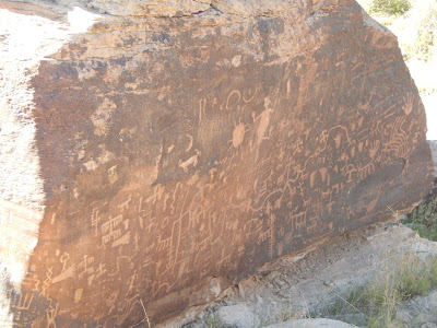
This area was called Newspaper rock because of over 800 different pictographs that have been found. 


Wednesday, April 26, 2023

Grand Canyon

So Monday we went and got some groceries for the week, explored the visitor information centre in Flagstaff at the old train station. We then came back to the Condo and just relaxed the rest of the day. We did a lot over the last five days and decided to take the day off.

Tuesday we got up early had an egg McMuffin at MacDonalds and headed north to the Grand Canyon. We got the park at about 9:30 in the morning found a parking spot and headed to the visitor centre, unfortunately it was closed on Tuesday and Wednesdays because they don’t have enough staff. We will make sure to go back next week when it is open. We then went to the bus station, they have three routes that have hop on hop off shuttle buses that take you around the park. They all have bus stops all over the park that drop you off at campgrounds, hotels, view points, the market and train station. There are three routes that stop and go at every location every 10 minutes. The buses are all free and it is the only way to get around the park.  We started off at Mather Point, which is on the orange route. We then walked along the rim all the way to Yavapai Point and Geology Museum. 


At the geology centre we learned that the Grand Canyon was first explored by boat from 1834-1902 by John Wesley Powell, he led two expeditions down the Colorado River to answer this key question, why did the Colorado River cut canyons through mountains instead of flowing around them? He discovered the “river” had the right of way, it was the saw that cut the mountains in two. John Strong Newberry established that the river carved the canyon by erosion over a long span of time. His view countered other geologists beliefs that earthquakes formed the canyon. He laid the ground work that the river did it.

After completing the East section of the orange route we transferred to the blue route which took us to the red route which is an 7.5 mile section that has the best views of the Colorado river. We started off at the Bright Arrow Trailhead. This is the trail that you can either walk down to the bottom of the canyon or you can take a mule ride.  From 1903 to 1912 this trail was privately owned by Ralph Cameron, he charged $1 for every person who used the trail. In 1912 the local county assumed trail control and they charged a toll until the park acquired the trail and eliminated the toll in 1928. The trail descends 4500 feet down to the Colorado River.


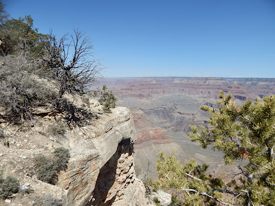
The little white lines that you see is the trail down into the Canyon


This green area at the bottom of the canyon is called Indian Garden, a green oasis where for centuries the native people called it home. In spring and summer they grew many vegetables, they lived without interference until the late 1800’s


This is the Kaibab trail suspension bridge. It was built in 1852 by the American Society of Civil Engineers, it was the only bridge to cross the Colorado river. Building in such a remote area was extremely difficult. The bridge is 400 feet long and was designed to carry foot traffic, horse and mules and was made of components that had to be carried down to the the canyon. 42 men, mostly members of the Havasueai tribe carried 550 foot long, 2300 pound suspension cables 7n miles down the trail. 


Here are a couple of more pictures of the Colorado river, it was hard to spot sometimes because it was so muddy. It blended in with the landscape. They had record snowfall in this area this year. The north rim to the park usually opens up some time around the beginning of May but this year they aren’t planning to open until June.  I am not sure if the water every gets crystal clear, probably stays pretty muddy just like the Fraser in BC.  The Colorado river has 15 dams on it, the most for a river completely in the United States. The Columbia River basin has 29 dams but some of those are in Canada.


Even with all the dams the water flow through the canyon at 484,684 litres per second, that is enough water to fill an Olympic swimming pool full in 5 seconds.


We finished off the red route at Hermits Rest. In 1911-1912 the Santa Fe Railway built both a trail and a camp to serve the blossoming tourist trade. They built it 9 miles from the train station to avoid the tolls on the privately controlled Bright Angel Trail. With some sandstone paved sections the Hermit Trail was considered the finest trail in the canyon. It was named the Hermit Trail after a Canadian prospector Louis Boucher who had staked claims below the Hermits rest. He was described as a kind, gentle sound, though not officially a hermit, this is who it was named after.

Hermits Rest was designed by pioneer architect Mary Colter whose distinctive style helped  shape the architecture of the Southwest and the national parks.  After an 8 mile buggy ride on unsaved roads you stopped at Hermit’s Rest for a refreshment before the journey back to your hotel.


This is the fireplace that takes up the entire back wall of the building.


We took the red bus back to the train depot, transferred back to the blue bus which took us back to the parking lot. We started the trek home.  This is the sunset just before we hit Flagstaff.