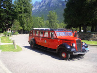
 We were up early again this morning, we have noticed that in the mountains it really cools off at night. We didn’t have an frost but the windows of the vehicles had condensation on them. We packed a lunch and we were on the road by 8 am, it was clouded over, so we left the doors on because it was a little chilly. We headed towards St. Mary’s and the gate to Glacier Park.
The Road to the Sun was open all the way so that was the plan. There was also seven virtual caches along the road so that should take us to a couple of places that we wouldn’t normally see along the road. We made it to the gate at East Glacier, asked the park ranger what the weather was going to be like and she said that the overcast sky was supposed to burn off by about 10 am, so that was good news. The first stop was the seventh virtual; we were doing the road backwards according to the GPS but who cares.
The virtual was called Sun Point. We made it to the parking lot and started off when we discovered that we had to take a trail about ¼ of a mile to the destination. Unfortunately you are not allowed to take dogs on any trails in National Parks; there were signs up all over the place. I guess they don’t have many responsible dog owners down south. We decided that I would stay in the parking lot area and Len would hike the trail and then he would come back and we would switch. While I was waiting for Len, I talked to a tour bus driver and he told me of a couple of museums in the area that we might want to visit. Len came back, took Lindy and I headed out to the point. It was a very pretty view. There was a huge sun dial that also was a compass and gave you the names of the surrounding area, got some very nice view shots with the camera.
Next on the trip was Baring Falls. This was quite a hike, so Len went on this one and Li
We hit two road stoppages as they are fixing the road. They are
The drive down to the bottom was great; we didn’t stop until we made it to the Lodge at Lake MacDonald. There were not very many places to park, so Len drove around while I ran into the Lodge to do the cache. This lodge was set up exactly like the Prince of W
The next stop along the route was a virtual cache called the swim hole. It was a bit of a climb down to the area, but was absolutely beautiful. Len and Lindy stayed in the Jeep while I made my way down to the river. There was a large number of people taking advantage of the weather and I am sure the very cold water, considering it is a glacier fed river, hence the colour of the river.
After the swimmin
The next stop was 
The pictures look like their close ups but I was actually only standing about five feet away from the baby. Good thing mom could careless that we were there because she jus
After the traffic had passe
We then headed back down the mountain and a nice leisurely drive back to the campground.


No comments:
Post a Comment